Building plan (Local Planning Authority)Sanctioned 8 Oct 2024No. KPA/LAO/14/2024-25/1735
RERA extensionsNone on the filingFiling read 20 Oct 2026
RERA complaints0✓ClearClear
Land conversionConverted 21 Nov 2022District Commissioner Bangalore Urban District
Permits
Validity
Disputes & cases
Are there court cases or buyer complaints on this project?
Locked
Cases on the landNo cases
Cases on the builder16 cases
RERA complaintsNo cases
Builder's other projectsNo cases
Filed onCase no.Filed atWhat it's aboutStatus
₹ ••,•••
•• %
•• ••• ••••
•••••
₹ •.•• Cr
•• of ••
Unlock this full report
Contract & costs
What does a buyer commit to?
Locked
Forfeiture, agreement•• %
Forfeiture, allotment letterNot verified yet
Transfer feeNot verified yet
Maintenance includedNot verified yet
Cancellation
Forfeiture
•• %
•• %
•• %
Valuation
What is it worth?
We haven't verified the rest of this yet.
Sign in first, then it is one click.
Recent price, super built-upNot verified yet
Recent price, carpetNot verified yet
Phase 1 → Phase 2Not verified yet
Gross yield, per sq ftNot verified yet
This project
Price
Price per sq ft, super built-up
Location & risks
What is the location like?
Height above nearest drainNot verified yet
Groundwater, taluk average16.9 m below groundBengaluru South taluk, July 2023
Water supply, as filedLocal authority (Gram Panchayath)Declared by the promoter
Metro, operationalabout 5 kmSilk Institute
The site
Construction & progress
How is it being built, and when will it be ready?
Clear1 clear
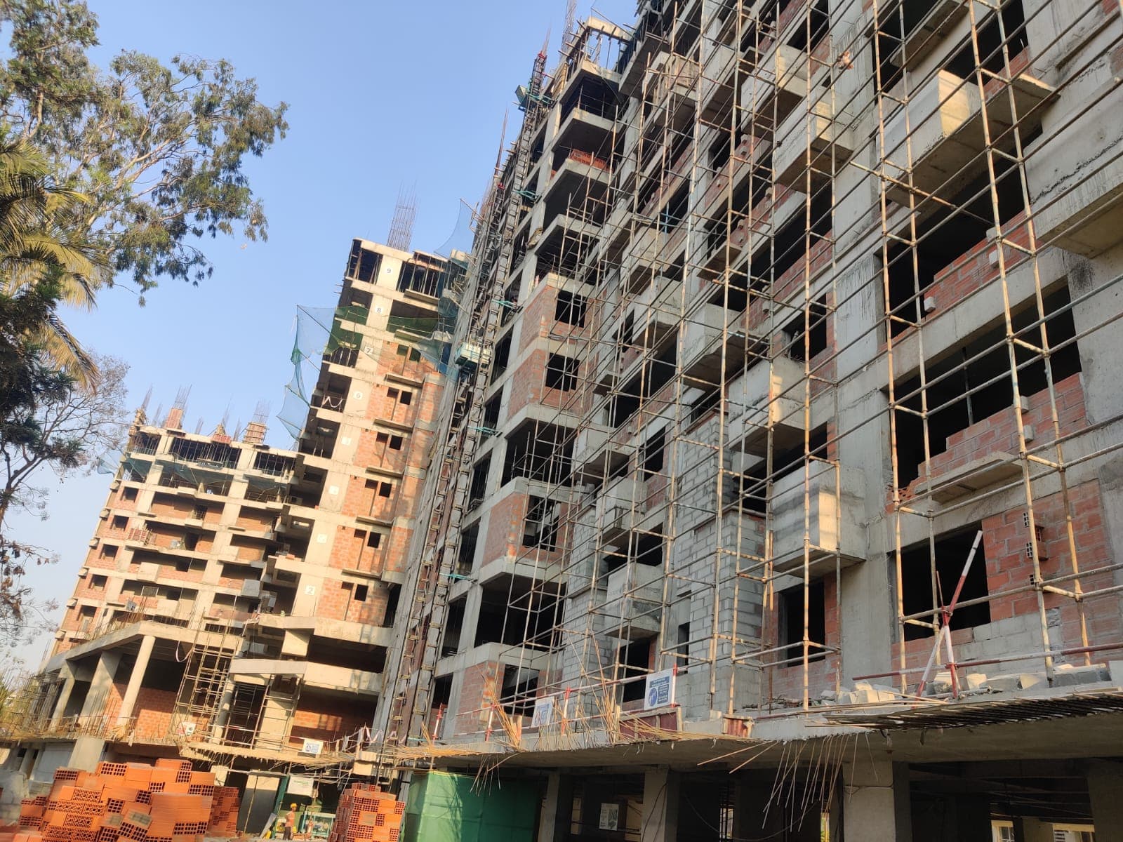
Completion63%As of Q2 2026-27, promoter's return
Possession, agreement1 Dec 2029Agreement for sale, p. 12
StructureNot verified yet
Structural safety certificateNot verified yet
Progress
Developer
Can the developer deliver?
Receivable, sold flats₹44.42 CrAs of Q1 2026-27
Cost left₹42.42 CrAs of Q1 2026-27
Sold100 / 173As of Q2 2026-27
Sold in Q2 2026-271 booking cancelled or corrected (101 → 100 sold)Net change in booked flats
Funding
Estimated cost
Loan & collateral
Can it be financed?
Value, 3BHK ANot verified yet
Max loan, 3BHK ANot verified yet
Borrower marginNot verified yet
Developer's project loanNo borrowing declaredAs declared in the K-RERA filing
Value & LTV
3BHK A
Not verified yet
Calculation
Not verified yet
Conditions
Collateral checks
Data room
Documents filed for this project
Documents filed120On K-RERA
Available10083% of filed
K-RERA only20
Approvals with a validity date1Valid today
Approvals & NOCs
What we read
Fire NOCIssued 14 Mar 2024Filed as Fire Force Department, pp. 1, 3
Airport height NOCNOC ID HOSU/SOUTH/B/110723/822979Filed as Airport Authority of India, p. 1
Pollution board consentValid until 24 Sep 2029Issued 25 Sep 2024
Environmental clearanceIssued 1 Dec 2023Filed as SEIAA, p. 1
Available
K-RERA only
Available
1 pageAvailable
2 pagesAvailable
1 pageAvailable
K-RERA only
K-RERA only
39 pages3 factsAvailable
6 pages1 factAvailable
9 pages3 factsAvailable
12 pages3 factsAvailable
2 pagesAvailable
K-RERA only
K-RERA only
K-RERA only
K-RERA only
K-RERA only
K-RERA only
Filed 28 Oct 20241 pageAvailable
Filed 28 Oct 20242 pagesAvailable
Filed 28 Oct 20241 pageAvailable
Source: K-RERA project page and the documents filed there, as read by us. 58 documents filed with K-RERA, identity papers and photographs, are left out of this list.
Unlock this full report₹99 for this report · opens Contract & costs, Title & ownership and Disputes & casesUnlock
Imagery: Esri, Vantor, Earthstar Geographics
Survey plots around an approximate filed pin, with its uncertainty ring, on satellite imagery. The outlines are the land of each survey number, not buildings. Survey plots around an approximate filed pin. The dashed ring is 1 km: nine in ten approximate pins checked against surveyed land sat within it, so the site is most likely somewhere inside it, not at its centre. This project's survey numbers are not matched to the plots yet, so none is marked as its land.
Survey plots, KGIS cadastral
Road, stream, tank or settlement (not a plot)
Approximate location: the filed pin, good to the neighbourhood, not the plot
Map of drains, lakes, metro, high-tension lines and government-flagged flood locations within 3 km of the filed pin, with rings at 3 km. Approximate location: the filed pin, good to the neighbourhood, not the plot. The dashed ring is 1 km: of the approximate pins that could be checked against the surveyed land, nine in ten sat within it.
Storm drain, primary
Storm drain, smaller
Lake or tank
Metro lines (dashed: planned)
High-tension line, 765, 400, 220 and 66 kV
Its corridor, to scale
Approximate location: the filed pin, good to the neighbourhood, not the plot
Everything here is as filed by the promoter with Karnataka RERA or as recorded in Bhoomi land records, and can be stale or wrong at source. Verify against certified records before you transact. Open Primus Darpan in the interactive atlas
•• ••• ••••
Title
Title report
•• %
•• ••• ••••
•••••
₹ •.•• Cr
Charges
•• ••• ••••
•••••
₹ •.•• Cr
•• of ••
Boundaries
Schedule in the EC vs KGIS neighbours
Not verified yet
Encumbrance certificate, Form 15
Not verified yet
Survey sketch
Survey sketch filed with K-RERA
Sketch, sanction and mutation vs KGIS map
Not verified yet
Land record
Survey plots · KGIS cadastral
Filing vs KGIS map
•• ••• ••••
•••••
₹ •.•• Cr
•• of ••
The RTC of each filed survey
Not verified yet
Ownership
Share of sales revenue
Not verified yet
Joint development agreement
•• of ••
₹ ••,•••
•• %
•• ••• ••••
Unlock this full report
₹99 for this report opens Contract & costs, Title & ownership and Disputes & cases for this project, yours to read for good.
Valid as of this reportValidity ended
Approval letters
Building plan (Local Planning Authority)
Sanctioned 8 Oct 2024 · No. KPA/LAO/14/2024-25/1735
Power NOC (BESCOM)
Filed with the registration
Fire NOC
KSFES/NOC/359/2023 · issued 14 Mar 2024 · building height 44.85 m
✓Clear
Environmental clearance
SEIAA 190 CON 2023 · EC identification no. EC23B038KA139324 · issued 1 Dec 2023
✓Clear
Airport height NOC
NOC ID HOSU/SOUTH/B/110723/822979
Pollution board (CFE)
consent order CTE-345194 · issued 25 Sep 2024 · valid until 24 Sep 2029
✓Clear
Water supply NOC
Filed with the registration
RERA
K-RERA
RERA extensions
None on the filing
RERA complaints
0
RERA completion date
1 Dec 2029
Registration certificates
PRM/KA/RERA/1251/310/PR/111124/007217
Land use
Conversion order
Land conversion
Converted 21 Nov 2022 · District Commissioner Bangalore Urban District
Survey numbers
176/1
₹99 for this report opens Contract & costs, Title & ownership and Disputes & cases for this project, yours to read for good.
•• %
•• %
Agreement and allotment letter
•• %
•• ••• ••••
•••••
₹ •.•• Cr
•• of ••
Payments
Payment plan
Not verified yet
Agreement for sale
•••••
₹ •.•• Cr
•• of ••
₹ ••,•••
•• %
Fees
Agreement for sale
₹ •.•• Cr
•• of ••
₹ ••,•••
•• %
•• ••• ••••
Unlock this full report
₹99 for this report opens Contract & costs, Title & ownership and Disputes & cases for this project, yours to read for good.
Not verified yet
Form 4 certified totals
Not verified yet
Unit sizes
3BHK A: carpet vs rest
Not verified yet
Unit mix filed
1 BHK, 2BHK, 2.5 BHK (Total flats) · avg 70… 50%2BHK · avg 70 m² 18.5%2.5BHK · avg 84 m² 16.8%1BHK · avg 52 m² 14.7%
Map of high-tension power lines, storm drains and government-flagged flood locations within about 2 km of an approximate filed pin. Approximate location: the filed pin, good to the neighbourhood, not the plot. The dashed ring is 1 km: of the approximate pins that could be checked against the surveyed land, nine in ten sat within it.
High-tension line, 765, 400, 220 and 66 kV
Its corridor, to scale
Storm drain, smaller
Approximate location: the filed pin, good to the neighbourhood, not the plot
about 6 km, Mantri Lake view Appartment Next to Talagattapura Lake
Height above nearest drain
Not verified yet
Flooding
Site vs nearest drain
Nearest storm drain
about 0.5 km, tertiary drain
Nearest lake, tank or pond
about 0.5 km, an unnamed tank
Height above nearest drain
Not verified yet
Drains and lakes around the filed pin
Basemap: Esri, OpenStreetMap contributors
Map of storm drains, lakes and government-flagged flood locations within about 2 km of an approximate filed pin. Approximate location: the filed pin, good to the neighbourhood, not the plot. The dashed ring is 1 km: of the approximate pins that could be checked against the surveyed land, nine in ten sat within it.
Lake or tank
Storm drain, smaller
Approximate location: the filed pin, good to the neighbourhood, not the plot
Electricity · CCTV Surveillance · Community Hall · Indoor Sports facility · Gym · Power Backup · Water and Sanitation
Club House, built
30%
Electricity, built
0%
Outdoor Sports facility, built
0%
Swimming Pool, built
30%
Parks, built
0%
Water and Sanitation, built
0%
Kitchen handover
Not verified yet
Covered parking per unit
1.03 (178 covered spaces for 173 units)
Sewage plant
Not verified yet
Power backup
Declared by the promoter
Around it
Water
Groundwater, Bengaluru South taluk average
Ten-year July mean for this taluk: 23.2 m
Across Bengaluru South, the water table sat 16.9 m below ground in July 2023 (KSNDMC, a taluk average), shallower than the ten-year July mean of 23.2 m, and it fell 4.2 m over the year.
Water at a glance
Groundwater
Bengaluru South taluk average, July 2023: 16.9 m below ground
What it means
Not verified yet
Water below ground
16.9 m, the taluk average
Through the year
Not verified yet
Water supply, as filed
Local authority (Gram Panchayath)
Nearest city water main
Not verified yet
Distances
Within 3 km of the filed pin
Connectivity
Straight-line distance from the site
Nuisances
Distance from the filed pin
DOSL nuisance layer
Landfill or waste transfer station
None within 3 km
Completion, as the promoter reported it
As the promoter reported itPossession date in the agreement
Site photos filed with K-RERA, Q2 2026-27
Work left
By component, Q2 2026-27
Quarterly return, Q2 2026-27
Main structure
69% · planned by 21 Jan 2027
Electrical and plumbing finishing
10% · planned by 3 Nov 2027
Internal roads
Not verified yet
Club house
30%
Completion
63%
Completion, accountant
55.4% of the estimated cost spent
Dates
Dates
Filed dates
Possession, agreement
1 Dec 2029
Schedule end
20 Nov 2029
RERA completion date
1 Dec 2029
Work began, as filed
1 Dec 2024
Specified structure
What the promoter specified · not an inspection
Structure
Not verified yet
Foundation
Not verified yet
Wall material
Not verified yet
Wall thickness
Not verified yet
Concrete / steel grade
Not verified yet
Building heights, fire NOC
44.85 m on the fire NOC · 44.95 m filed
Specification sheet, page 1
Page 1
Page 1 of the specification sheet. The promoter filed this with the registration.
Map of drains, lakes, metro, high-tension lines and government-flagged flood locations within 3 km of the filed pin, with rings at 3 km. Approximate location: the filed pin, good to the neighbourhood, not the plot. The dashed ring is 1 km: of the approximate pins that could be checked against the surveyed land, nine in ten sat within it.
Storm drain, primary
Storm drain, smaller
Lake or tank
Metro lines (dashed: planned)
High-tension line, 765, 400, 220 and 66 kV
Its corridor, to scale
Approximate location: the filed pin, good to the neighbourhood, not the plot